This is the first part in a multipart series called Groundwater 101. Groundwater 101 provides the foundation for a good working understanding of groundwater—the source of drinking water for 75% of Minnesotans. There are three goals of this blog series: first, to introduce the basic science behind groundwater; secondly, to explore the impacts that agriculture can have on groundwater, especially in and around the Minnesota River Watershed; and thirdly, to summarize the role that government policies and agencies play in shaping our groundwater resources. Happy learning!
Groundwater is a big deal. That much is clear. When 75% of Minnesotans turn on the tap, groundwater comes out. About 30% of the world’s freshwater is groundwater. And plentiful, clean water is a key component of Minnesotan identity, even as lake levels drop, wells run dry, and seasonal floods cost the state millions of dollars. Despite that, and increasing press about groundwater resources, there’re still plenty of misconceptions and misunderstandings. However, just because groundwater concepts are tricky to grasp doesn’t mean that you can’t develop a perfectly good working understanding of our state’s underground water resources. My goal with this blog series is to provide the foundation for that understanding.
CURE’s ongoing Groundwater 101 blog series will first introduce you to basic groundwater hydrology; then I will discuss rural communities’ interactions with groundwater, especially in the context of the highly agricultural Minnesota River watershed; and finally I will look at the role that governmental agencies and policies have in shaping the state of groundwater resources in the state of Minnesota. As they are published, the installments will be featured in our bi-weekly newsletter and on our blog.
Minnesota’s groundwater provinces
One of the things that makes groundwater so complicated is the fact that invisible underground geology plays a huge role in how groundwater behaves—and in Minnesota, that geology is extremely varied. To reflect this variety, the DNR has divided the state into six groundwater provinces based on a combination of the surficial and bedrock geology for each region of the state. 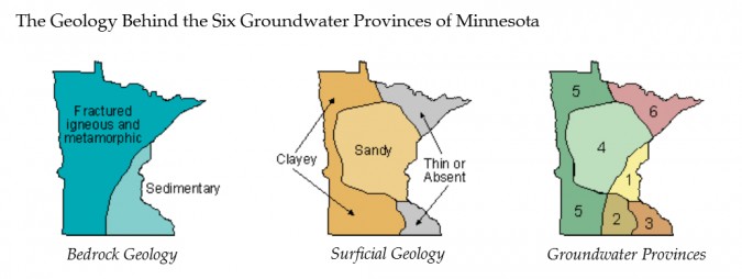
The bedrock is the base layer, a solid rock that may be exposed to the surface or may be covered by dozens of feet of unconsolidated material such as sand, clay, or glacial till. In Minnesota, there are two main types of bedrock: sedimentary layers of sandstone, limestone, and dolostone in the southeast; and very old, very hard igneous and metamorphic rock in the rest of the state.
Above the bedrock are three major categories of surficial deposits: clayey deposits in the western part of the state, sandy deposits in the central region, and very thin or absent surficial deposits that leave the bedrock exposed in the northeast and southeast.
When these two maps are overlain, it produces a third map that breaks the state into six different provinces. While the DNR does not use these provinces in any sort of regulatory capacity and acknowledges local variability within provinces, it provides the information with the recommendation that water planners take the unique characteristics of their region into account when evaluating the future productive capacity of ground-water resources.
What’s Geology Got to Do With It?
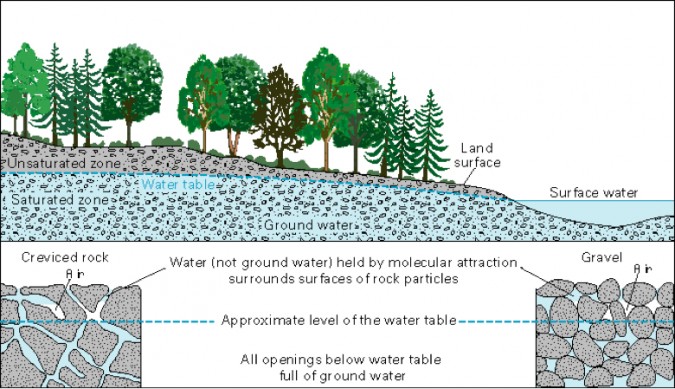
In some ways, the answer to this question is very simple—groundwater saturates the rocks underground, so geology has everything to do with it. Many people think of groundwater as an underground river, and while underground caverns and caves do allow for such formations in some regions of the world, this is rarely the case. So, instead of imagining a river in a cavern, think of a bucket of sand and gravel to which you have added water. The water will sink down into the gaps between the sand particles and gravel, completely saturating a bottom layer in the bucket. Above that wet layer, there will be a layer of damp to dry sand upon which you may place a few tin soldiers for realistic effect—you have just built a pretty decent model of an unconfined or surficial aquifer.
In fact, many of those surficial deposits of sand and clay are very like the sand in your bucket: loose or unconsolidated materials that have not yet been turned to rock. But even seemingly solid rocks may contain cracks or crevices that also hold water. Any water that has sunk down and fully saturated the surrounding rock is called groundwater; the rock that contains it is called an aquifer. The water table is the line that divides the saturated rock from the unsaturated rock above.
Three Simple Rock Features
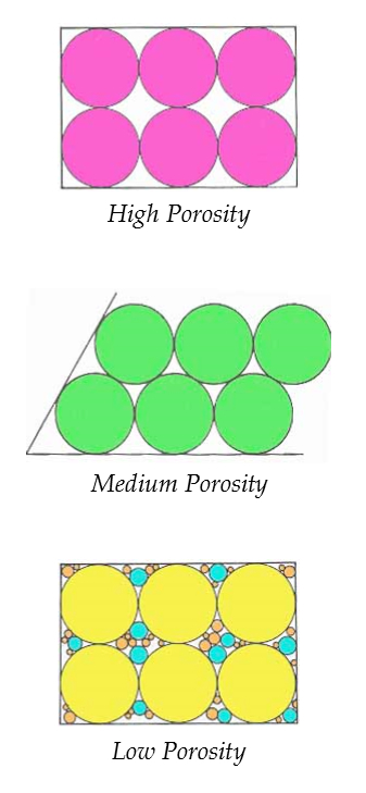 Groundwater does move, but very slowly because the water has to squeeze its way through tiny holes and cracks in the rock. And that is where geology becomes extremely important: different rocks have different water holding capacity and allow for different rates of flow, and this results in a huge variety of groundwater resources. There are however, three key, relatively simple factors to consider, and we have quantitative measures for these features.
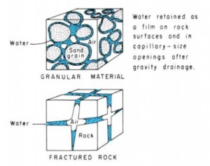
Porosity is the amount of void (air or water) space between particles in a rock or unconsolidated deposit; it is a factor of both the arrangement of rock particles and of the diversity of sizes. Porosity is measured as a percentage—the amount void space as a percent of the total volume of a rock. Specific yield is related to porosity, but it measures how much water will drain from the void spaces in a rock due to gravity. Because of surface tension, some water will cling to the surface of the rock particles, so specific yield is a percentage that is always less than porosity. Specific yield is related to the size of the pores—rocks or unconsolidated deposits with larger pores will have higher specific yields than those with smaller pores because smaller pores result in more particle surface area for the water to cling to.
Permeability, or hydraulic conductivity in groundwater-speak, is related to the porosity of a rock, but it also incorporates the size of and the connections between the pores to indicate how quickly water can actually flow. Hydraulic conductivity is given as a rate, such as millimeters/day.
Let’s look at an example that is common in Minnesota: clay, which is the major surficial deposit for provinces 2 and 5 in western and southern Minnesota. Clay is generally 33-60% porous—a highly porous material with a lot of void space that can be filled with water—think of how wet potter’s clay can become. However, because the individual clay particles are so small, the specific yield is very low—about 2% on average. That means while 33-60% of a saturated clump of clay may be water, the amount of water that will drain from the clay due to the force of gravity will only represent 2% of the total volume of clay. Thus a clay aquifer will yield little well water. Furthermore, its hydraulic conductivity, at 0.0009 – 0.9 mm/day, is very low, which means that a layer of clay can significantly limit groundwater movement. In comparison, wells-sorted sand often has a porosity of 25-50%, a specific yield of about 26%, and a hydraulic conductivity of 90 – 9000 mm/day (or .09 – 9 meters/day). The same measurements are applied to solid rocks as well; usually, the goal is to find aquifers made of rock with high specific yield and permeability, as this results in a high-yielding well. Sandstone is a favored aquifer material.
Back to the Six Provinces
Given this understanding of geology, it becomes easier to interpret the significance of Minnesota’s six groundwater provinces. Provinces 2 and 5, for example, have surficial clay deposits, which means that shallow wells are not likely to yield well. The hard igneous and metamorphic bedrock that underlies provinces 4, 5 and 6 is not very porous, but fractures or cracks in the rock may provide groundwater resources locally. Province 1, where sandy surficial deposits overlay sedimentary bedrock layers that include sandstone, should be a perfect groundwater sweet-spot where both surficial aquifers and deep bedrock aquifers provide plentiful water resources—though the White Bear Lake controversy indicates otherwise. Province 3 is a funny one, with lots of confined aquifers, a feature that occurs as a result of the layer cake sedimentary bedrock.
Confined Aquifers
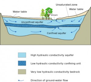
A confined aquifer occurs when a rock or unconsolidated deposit with very low conductivity overlays a permeable aquifer. The confining bed or confining unit that sits on top of the aquifer limits the exchange of water between it and surrounding aquifers. Thus the aquifers are isolated and the groundwater they contain may have very different characteristics, even though they are very close to one another. This makes an intuitive understanding of the local resources difficult to develop because two wells dug right next to each other but reaching to different depths may encounter very different groundwater resources.
Summary: What’s Geology Got to Do With It?
Geology is everything! Both unconsolidated materials like sand and clay and solid rocks like sandstone have empty spaces within the rock that can absorb water. Groundwater is the water that saturates these deposits and rocks in underground aquifers. However, because different rocks interact differently with groundwater, the groundwater resources in a certain area are closely tied to the geology of that area. Three key quantifiable features indicate how the groundwater in a certain kind of aquifer will behave: (a) Porosity, which is a measurement of how much void space is available to be saturated by water; (b) Specific yield, which is a measurement of how much of that water is will naturally drain out of the rock or deposit; and (c) hydraulic conductivity, which is a measurement of how fast water will move through that rock. Clay is an example of a poorly-yielding aquifer material; sandstone aquifers yield very well. Sometimes, however, there is a combination of rocks and deposits in a certain area, and an outcome of that is confined aquifers that have limited exchanges of groundwater between them and surrounding aquifers. This understanding of geology helps interpret Minnesota’s six groundwater provinces determined by the DNR.
Continue to Part 2 – Where Does Groundwater Come From? Where Does It Go?
Blog post by Ariel Herrod, Watershed Sustainability Program Coordinator.

