This is the second part in a multipart series called Groundwater 101. Groundwater 101 provides the foundation for a good working understanding of groundwater—the source of drinking water for 75% of Minnesotans. There are three goals of this blog series: first, to introduce the basic science behind groundwater; secondly, to explore the impacts that agriculture can have on groundwater, especially in and around the Minnesota River Watershed; and thirdly, to summarize the role that government policies and agencies play in shaping our groundwater resources. Happy learning!
In the last installment of Groundwater 101, I talked about the role that underground geology plays in influencing groundwater resources. However, stopping there may leave you with the impression that groundwater is this stagnant resource trapped in rocks underfoot, and that is not an accurate representation. While there are some fossil aquifers—groundwater resources that were deposited long ago and are no longer being replenished—most groundwater is as integral a part of the water cycle as rain or snow.
The Water System
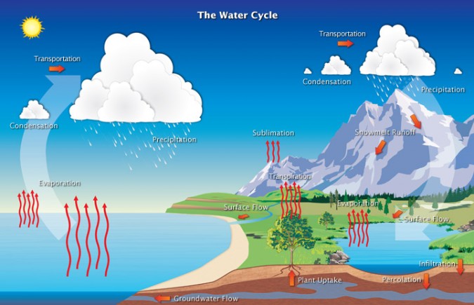
Though “the water cycle” is the common terminology, I have also heard “water system,” which I think better conveys the complexity of the movement of water in our environment. As with all cycles or systems, the starting point is somewhat arbitrary, but for this discussion, let’s start with precipitation. As Minnesota contains (most of) the headwater systems for 3 major watersheds, 99% of the water that enters the state falls from the sky as rain or snow.
 Upon reaching the ground, the water may travel one of three ways. Most people clearly understand surface flow because it is visible: we can see water traveling over land as run-off or rivers, lakes, and streams, but this only accounts for about 10-20% of the water that falls as precipitation. The majority of precipitation evapotranspires–that means that it is converted into water vapor either by simple evaporation from puddles, damp ground, or hot sidewalks or by transpiration from plants that absorb and then “exhale” water when they release oxygen. This evapotranspiration generally accounts for about three-quarters of precipitation.
The remaining water infiltrates the soil surface and then percolates deep into the ground to recharge the aquifers. A USGS estimate indicates that, on average in Minnesota, 20-25% of precipitation recharges the groundwater supplies. While groundwater does eventually flow to surface water bodies, this takes days, weeks, or much longer, dependent in large part on the underground geology.
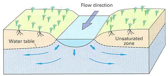
Direction of Flow
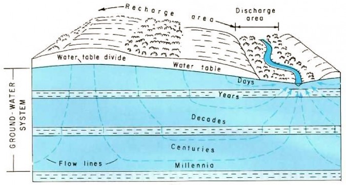
The image above indicates where recharge and discharge areas may exist on a landscape, with flow lines showing how groundwater moves towards surface water in a discharge area. Why does groundwater flow towards the river? Well, actually it doesn’t always, but let’s start with the example illustrated above. Just like surface water, groundwater movement in an unconfined aquifer is dictated by gravity: many say that it flows “downhill.” However, my brain has a really hard time grasping the image of groundwater running downhill–wouldn’t it just go straight down towards the center of the earth? Instead I suggest thinking of water in a glass and comparing it to the image above: where’s the contradiction? If you noted that the water table is not flat, while the surface of the water in your glass is, you are right on track.
Just as gravity makes sure that all the water in your glass has moved so that no water stands above the rest, gravity is working to create a level water table. Thus water will flow towards the lowest point in the water table. In groundwater-speak, you would say that groundwater flows towards the point of lowest hydraulic head.
 Often, the point of lowest hydraulic head is a body of surface water that is whisking away the groundwater, either by evaporation from a lake surface or by movement in a river channel. Because surface water moves so much more quickly than groundwater, the water is rapidly whisked downstream and groundwater continues to flow in that direction. However, in a stable water system, the rate of groundwater recharge is roughly the same as the rate at which water flows to the surface water and downstream, resulting in a steady water table level from year to year.
In some cases, particularly in arid regions where rivers carry water from snow or glacial melt upstream, the river recharges the aquifer, resulting in a cross-section that looks like this:
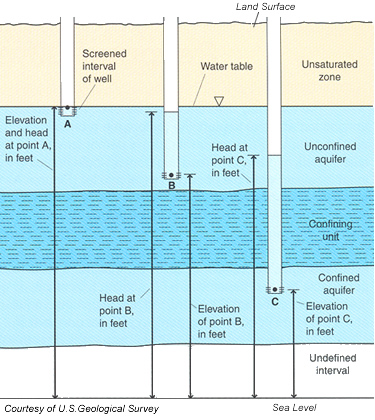
Regardless of the topographical features, however, the key point is that groundwater flows in the direction of the lowest hydraulic head. Hydrologists determine the hydraulic head at a given point in an aquifer by digging wells (or taking measurements from existing wells): the elevation of the water in the well (above sea level) is the hydraulic head. From there, they can calculate flow direction.
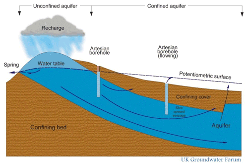
 Groundwater Flow in a Confined Aquifer
 Understanding the hydraulic head in terms of the water table only works for unconfined or surficial aquifers that do not have a confining bed over them, but never fear—the hydraulic head rule works for confined aquifers as well, and hydrologists perform the measurements in much the same way.
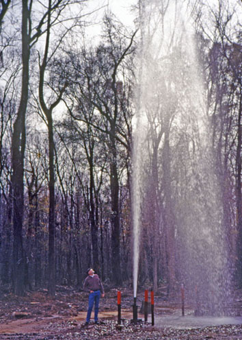
The only tricky part is that because confined aquifers are buried under sometimes 100s of feet of rock and water, the water in the aquifer may be under pressure. So, when a well borehole punctures through that confining bed, the water in the well may rise above the top of the aquifer; this is called an artesian well. In some cases, the aquifer is under enough pressure that water will jet above the surface of the ground; this is called a flowing artesian well.
The process for determining flow direction is roughly the same, however. Based on the different elevations of the water in the wells, hydrologists map out a sort of imaginary water table above the surface of the aquifer called a potentiometric or piezometric surface. The shape of this piezometric surface provides the same visual that the water table does, though the piezometric surface is a measurement not of where groundwater is, but rather of how much pressure the groundwater is under. Groundwater will flow to the lowest point in the piezometric surface, which is the point of lowest pressure, or, more precisely, the point of lowest hydraulic head.
Why Does Flow Matter?
 There is one key lesson to take from this: groundwater is a part of the water system, and it does move. As such, we need to think about it, even if we can’t see it. One obvious impact of groundwater’s movement is on stream flow: because groundwater moves so slowly, spring rains may not arrive to a stream or river until late summer, keeping water levels high even during dry spells. Groundwater can also carry contaminants meaning that a well “downstream” from a source of pollution can be contaminated just like a downstream stretch of a river. In that case, being able to calculate rate and direction of groundwater flow is extremely important. Finally, just as human intervention can obviously change surface water flow, pumping groundwater or creating impervious surfaces that prevent recharge can impact groundwater flow—and thus the movement of water in the entire system.
We can’t see it, but our understanding of and ability to measure groundwater is increasing rapidly; as such we must take this knowledge into consideration when making decisions about water resources. The remainder of the blog series (with an installment to be published every other week) will explore the some of these water resource decisions in more detail with a continued focus on the science behind them.
Summary of Where Does Groundwater Come From?
Groundwater is an integral part of the water system, which means that the story starts with precipitations. Rain or snow falls, and the precipitation infiltrates the soil and eventually percolates to the water table, where it earns the title groundwater. Then the groundwater moves slowly in the direction of the lowest hydraulic head, measured by the elevation of water in a well. In an unconfined or surficial aquifer, that lowest point may be a stream, lake, or river. In that case, the groundwater recharges the surface water body days, weeks, or even months after it has rained. In a confined aquifer, groundwater is often under pressure, resulting in artesian wells that rise above the surface of the aquifer. However, hydraulic head and groundwater flow are calculated using the same metrics. Understanding groundwater in relation to the larger system is critical to making wise water resource decisions.
Continue to Part 3 – Why Should I Care?
Blog post by Ariel Herrod, Watershed Sustainability Program Coordinator.