“Can I ask you a question? It’s probably really dumb, though. But, what exactly is a watershed?”
That, my friend, professional acquaintance, or perfect stranger, is not a dumb question. Not in the least. Here, let me try to explain:
A body of water’s watershed is the land area that drains surface run-off to that body of water. That is to say, if a drop rain falls on land and the ground is saturated, the water will run downhill until it ends up in a body of water, such as the Minnesota River. In this case, the drop of rain would have fallen within the Minnesota River Watershed: the watershed includes all the land (and other upstream surface water) that funnels rain or snow water to the Minnesota River. Because water runs downhill, topography defines the boundary of a watershed—ridges or high points in a landscape form the line between one watershed and another.
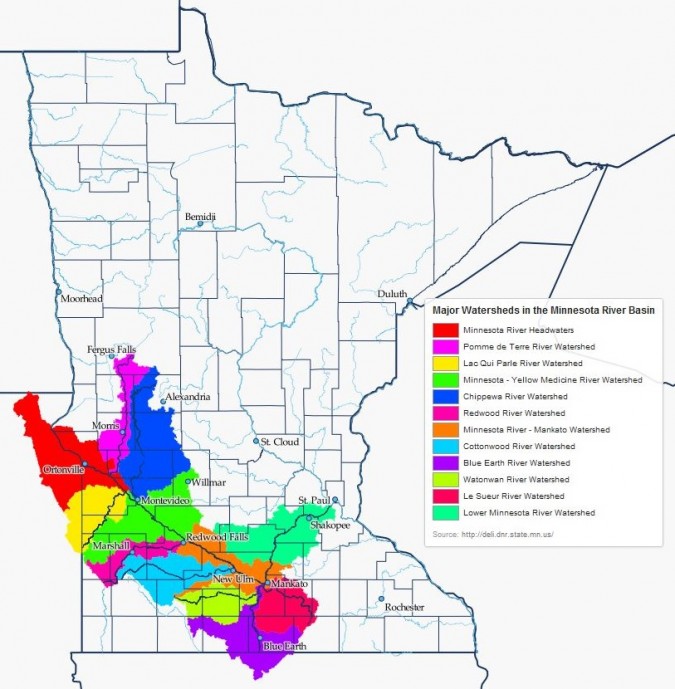
It gets a little tricky, though, because watersheds nest inside each other. Look, for example, at the watershed map below. Rain falling in Marshall would run first into the Redwood River, so Marshall is within the Redwood River watershed. However, water in the Redwood River flows eventually into the Minnesota River, so Marshall is also in the Minnesota River watershed. And, because the Minnesota River flows into the Mississippi River, Marshall is in the Mississippi River watershed, too.
How many watersheds are there?
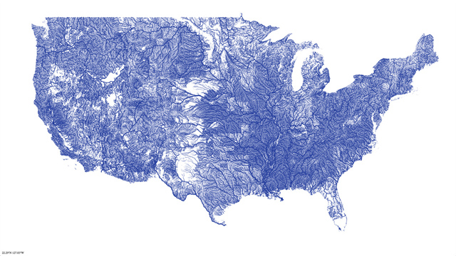
Yet each of the “watersheds” I named is in some ways arbitrarily defined. Yes, all the land in the Redwood River watershed drains into the Redwood River. But a watershed is really defined by a certain point past which water flows. The DNR (Minnesota Department of Natural Resources) Major Watershed named for the Redwood River really refers to that land area that will drain water through the point of the confluence of the Redwood River and the Minnesota River. If you look at the map of waterways in the United States, you’ll see that there are thousands of waterways, and each point on each waterway has its own watershed, in which the watershed of one point encompasses the watershed of an upstream point. Thus, if we use the scientific definition of a watershed, there are an infinite number of watersheds in the region, state, and country. I know that infinite watersheds seems overwhelming, but bear with me because others agree and have tried to clarify things.
To address the practical uselessness of infinite watersheds, the federal government, through the USGS (United States Geological Survey) and the NRCS (Natural Resources Conservation Service), defined Hydrologic Units based on topographic data. Each of these Hydrologic Units has a code, called the HUC, with the number of digits in the code increasing as the size of the watershed decreases. The relative size of a watershed is often referred to by the length of the HUC. For example, the watershed map above shows all the HUC-8 watersheds in the Minnesota River Watershed.
The Minnesota DNR built upon this classification to provide a more detailed look at waters in Minnesota. The MN DNR Major Watershed is equivalent to the federal HUC-8. There are 81 Major Watersheds in Minnesota, and these watersheds are the basis for most administrative watershed work, such as the Watershed Projects or Associations. Furthermore, the Board of Water and Soil Resources’ One Watershed, One Plan program encourages the development of watershed-level plans for each of the 81 Major Watersheds in the state.
”Okay, but why does an organization about ‘the River’ keep talking about watersheds?”
While the nomenclature is all very confusing, there is an important lesson to take from all this: you live in a watershed. No ifs, ands, or buts. In Minnesota, rain and snowfall on your home and the land surrounding it, and that water flows downhill and ends up in a body of water somewhere. Which watershed you live in will tell you which body of water your practices on the land affect. Thus, we use watersheds as a geographic unit—a certain defined area—to help us understand why our waterways are in the state that they are in.
Land Use, Watersheds, and Rivers
This is the key message: what happens on the land is very important for an organization concerned about water quality because the path that a drop of water takes from the place where it lands as a raindrop to the river dictates the state of the river. Does it pick up contaminants along the way? Does it move quickly, leading to erosion or flash floods almost immediately after a rainstorm? Does it even travel overland to the river, or does it sink downwards, joining the groundwater reserves underground first? The answers to these questions shape the river and are shaped by the land in the watershed.
In this way, the quality of water in the river is an indicator as much as it is a goal in and of itself. If our rivers are clean and safe for drinking, swimming, and fishing, it means that the watershed is also healthy and functioning as an ecosystem should. That’s why the Minnesota River is the basis for our work, but why the landscape from Ortonville east to Shakopee and just about Fergus Falls south to Blue Earth is where we seek to make change.
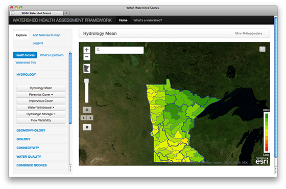
The Jargon Disconnect
But here’s the thing: as much as it’s important that you understand a watershed, what’s more important is that many people don’t and that most of them are too embarrassed to ask the really good “dumb question.” If we do not overcome this language gap, it will not matter how well a few of us understand all the intricate workings of watersheds, water quality, and river health. As long as water professionals toss around words most people don’t know, the movement to improve water quality will never have the sort of citizen support and public backing it needs. This much I understand.
Eric Eckl, founder of the marketing and public relations firm Water Words that Work, LLC, explains this concept very well. Basically, if you start talking to someone about something he doesn’t understand, he might have the self-confidence to ask for clarification. But there’s also a good chance that he won’t want to admit ignorance and will instead seek to get out of the uncomfortable and embarrassing situation as quickly as possible.
So, what happens when I say, “Hello; nice to meet you. I’m the Watershed Sustainability Program Coordinator for CURE. At CURE, we ‘broadly pursue strategies to raise public awareness and engage policymakers on environmental and community issues that affect the watershed.’”? If I’m lucky, the person I’m talking to says, “Oh, yes! I live in the Watonwan River watershed, so that’s kind of downstream from your offices in Montevideo.” And if I’m really lucky, the person says, “So, I have a kind of dumb question…” But there seem to plenty of opportunities for someone to feel alienated the moment I introduce myself, and that is not conducive to building a meaningful network.
That all makes sense. I don’t have an answer for this though: What should we do?
Is there an answer?
One tactic is to simply reach out and educate as many people as possible in the clearest possible way about what a watershed is. We are working on this. It’s why I sat down to make a map of the Minnesota River Watershed—because we didn’t even have one of those on our website. It’s why I’m writing this blog.
But I also know that there is a fine line between explaining something new and interesting to a stranger I meet at a gathering and offending someone by providing a simplistic explanation of a concept she already understands. And when I meet someone, I don’t know how to decide if she needs the explanation or not.
Another answer is to stay away from exclusive, jargon-y words. This makes a certain sense for a first meeting, but, given that our state agencies and policy-makers will keep on using them, we can’t keep the public in the dark. We also can’t lose the opportunity to explain the most important lesson that comes with understanding how watersheds work—that everything you do on the land affects the river, lake, or stream close to you.
I have also heard that we can take advantage of the relative ignorance about the word “watershed” to change the language entirely. Since the word watershed implies that the ultimate goal is to “shed,” or get rid of, water, maybe we should switch to another term, like “catchment basin,” which emphasizes the ability of the land to hold water. But if watershed is the word the DNR, the EPA, the NRCS, the UMN Extension office, and so on are using, would CURE just confuse the issue by talking about catchment basins? Does “catchment basin” even make more any more intuitive sense than “watershed”?
I don’t know, guys. If you have insights I would love to hear about them in the comments section. I do know that this is a conversation watershed professionals need to have, amongst themselves and with the public. Often, after someone asks me “the dumb question,” I ask them how I could make my explanation clearer, in what context they hear the word “watershed,” whether “catchment basin” makes more sense to them… In short, I try to have a conversation about the language that I use in my everyday work. So, please, feel encouraged to ask a water professional if you don’t understand what she is saying, and then also feel encouraged to critique the explanation you are given.
All talk and no action is no fun. But you can’t have action if you can’t talk about it. Talking, especially as we work together, is a really important place to start. Please, talk with me.
Post by Ariel Herrod, CURE’s Watershed Sustainability Program Coordinator.

